Life Along the Green: How Placemaking Design Can Invigorate Public Transit Routes and their Destinations

By Aidan Coleman

As I enter my second year as a Brookline resident navigating the Greater Boston area without a car, I’ve begun to reflect on how much of my life revolves around the MBTA, and more specifically, the Green Line D branch. Work, groceries, fitness, shopping, dining, and entertainment are all integrated into my routine along this branch of rail. With critiques and talks of improving the MBTA in the news recently, I’ve been contemplating as a designer about how to improve the user experience by incorporating more programming and placemaking ideas into locations. In my research, I found that there is a growing priority on transit-oriented developments (TOD) in the Boston area trying to boost activity around transit stops. As defined by the MBTA, TODs are “compact, walkable developments at or near transit stations, generally including a mix of uses,” (MBTA Realty). There are various TODs accessible from the D line that incorporate many established “good placemaking design” ideas, but these TODs will require that extra spark for human activity if they aim to prosper as transit-oriented destinations.

My main uses for the Green Line along the D branch (Fun, Home, Food, Work, Something New!)(Diagram by Aidan Coleman, map underlay from Google)

My main uses for the Green Line along the D branch (Fun, Home, Food, Work, Something New!)

(Diagram by Aidan Coleman, map underlay from Google)

Fenway/Kenmore

As I’ve observed through my years of college and currently as a young working professional, the Fenway/Kenmore area has seen remarkable change over the past few years. I would easily consider it the center of entertainment in the west portion of Boston based on its existing sporting and music venues alongside the night and restaurant scene that these venues greatly supplement. Its popularity has no doubt benefitted from its relative location to the many surrounding colleges, and its recently constructed high-end apartment buildings are surely helping as well. The area is supplied with ample entertainment and human activity, but only recently has welcomed a specifically designed social gathering space that takes advantage of qualities of designed parks or squares in urban areas.

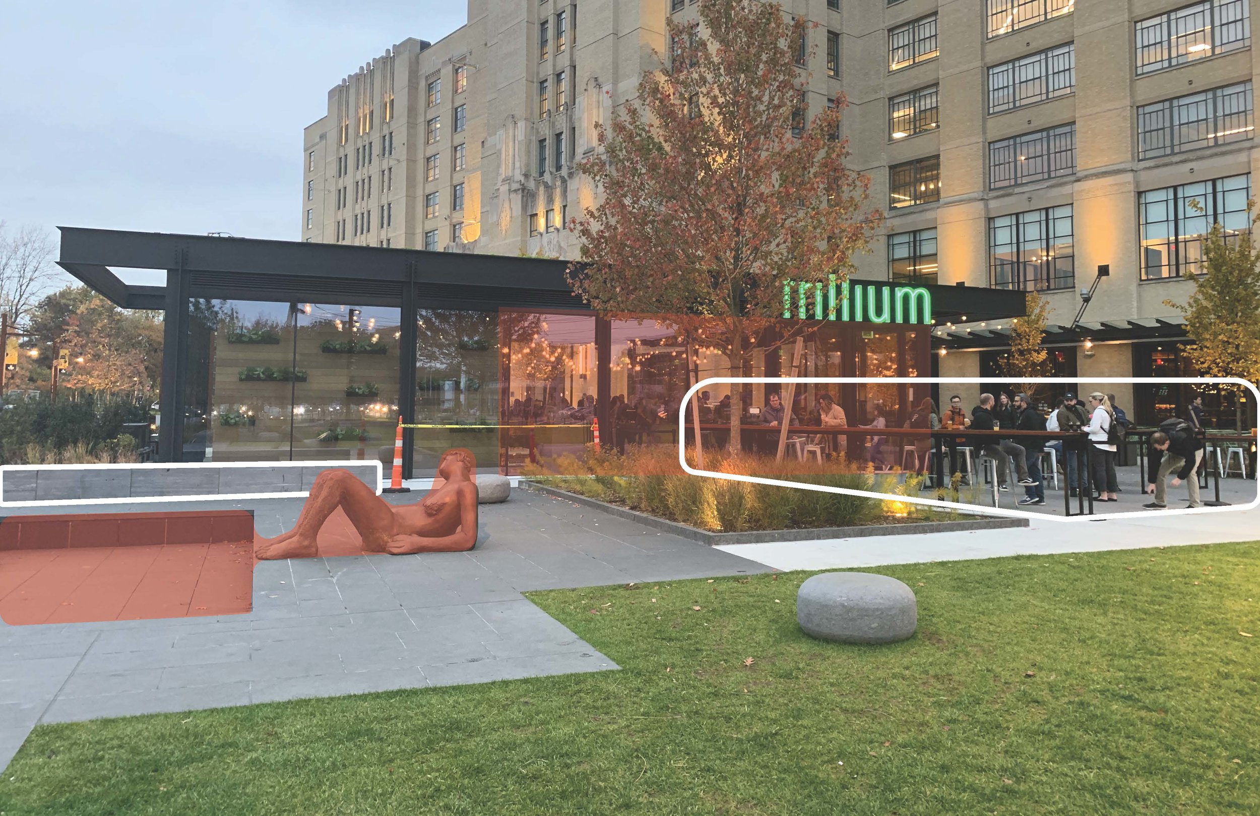
Fortunately, the Time-Out Market project was able to embrace many aspects of placemaking and TOD design. It gave us a new food and gathering experience with a large food hall, a connected lawn and beer garden on top of a former surface parking lot, pushing the surface lots to a garage underground. On top of that, it is directly adjacent to the Fenway T stop for easy access. I’ve found myself wanting to spend time there, either by going to eat with friends or enjoying a coffee and donut by myself, but it seems to also be an attractive location for social media photography, where one can observe people playing games on the lawn or taking pictures with the funny fountain statues. At its core, I think the project is a great example of placemaking design because it invites people to casually stop for free and people watch, with the option to engage others socially with food or games, if they choose. Since a lot of the entertainment in Fenway comes at a cost, the Time-Out Market gives people the welcomed option to pause and spend time without commitments or obligations.

 
Time-Out Market Gathering.jpg
 
 
Gathering spaces (outlined) and their adjacent attractions (in red) at Time-Out Market(Photos by Aidan Coleman)

Gathering spaces (outlined) and their adjacent attractions (in red) at Time-Out Market

(Photos by Aidan Coleman)


Chestnut Hill

Chestnut Hill contains a few developments; with the Chestnut Hill Mall, Chestnut Hill Square, and The Street. I happen to enjoy The Street’s convenience as a stopping point for groceries after work and its connection to the bus line that runs near my house. Each development has done its best in creating convenient and attractive retail and dining locations, but The Street feels the most accessible by the MBTA. The Street has shown some thought in designing pedestrian scale outdoor spaces around its dining spots, but are the spaces worth the visit when someone is done being a consumer of goods, foods and services? The main gathering area seems to draw people for yoga and family events, but when those events aren’t happening, the gathering space is only occupied by retail and food consumers passing through from the adjacent locations.

While The Street offers a lot to visitors in terms of shopping, and does well to host as many events as they can at their green gathering space, but I think the argument for better placemaking lies within a location’s ability to maintain a human presence even when the events aren’t happening. It’s a predicament that a public space like Government Center Plaza has faced even though its surroundings are highly populated. When we compare The Street to Fenway’s Time-Out Market, the differences in activity can be attributed to the targeted demographics, and available gathering space. Time-Out Market can target the variety of college students and young professionals who want to come and hang out in neutral gathering spaces outdoors or indoors. The Street seems to primarily draw families and shoppers with vehicles. They visit for restaurants or enjoy shopping on the weekends or after work, but the only neutral gathering space is an outside green space. At night or in bad weather, people visiting The Street could be more likely to eat/shop and leave, as the attractions require more of a purpose and there are limited options for gathering and people watching in a space that doesn’t require purchasing goods.

 
The Street Gathering 2.jpg
 
 
Gathering spaces (outlined) and their adjacent attractions (in red) at The Street at Chestnut Hill (Photos by Aidan Coleman)

Gathering spaces (outlined) and their adjacent attractions (in red) at The Street at Chestnut Hill (Photos by Aidan Coleman)


Riverside Station

One ambitious TOD proposal undergoing review at the end of the D line is Riverside Station. Currently, the station and its parking lot only serves as a transportation access point where the main use is to jump on the train and head back and forth to work. The state of the site is more of a place made for cars, and the vision in the redevelopment strives to add more uses to the site so it can more steadily be a place for people to live, work, shop, and gather. The project proposes to develop more than a million square feet of a mix of housing, offices, retail, public space, and parking (Boston Globe). This along with other changes and additions will bring about a monumental change to the area. Abutters believe the scale of the development is too large for the site and that the development will bring more congestion to the area’s infrastructure and schools (Newton LFIA.) Mediating ambitious goals of a TOD and addressing the concerns of the neighborhood residents is now a major focus.

In evaluating this project’s proposed placemaking qualities, it seems to check off many positives. It will mix uses, have transit, pedestrian, and biker accessibility, and will contain multiple gathering spaces in the form of greens, urban squares, and even a green amphitheater. The question from me is whether there will be enough programmed activities to host the workers, commuters, residents, and hotel visitors that plan to make use of the site. Besides living, working, shopping, and dining, this TOD must do its best to offer an experience that engages human interaction, or at least lets you watch it, if it is to become a successful placemaking example.

Gathering spaces (outlined) and their adjacent attractions (in red) at the proposed Riverside development(Diagram by Aidan Coleman. Underlay Image from riversidenewton.com)

Gathering spaces (outlined) and their adjacent attractions (in red) at the proposed Riverside development

(Diagram by Aidan Coleman. Underlay Image from riversidenewton.com)

While designers and developers can do all they can to install and program spaces so that they can be comfortable and full of people, the key point in creating a steady human presence is giving people a platform for social engagement so they have the option to interact with people, or just sit back and watch interactions take place. The developments on the Green Line share common successes in placemaking such as ease of pedestrian access and mixed programmatic uses, which can draw different demographics and a steady flow of people throughout the day, but what adds that extra placemaking excitement comes from the neutral gathering spaces that invite the opportunity for people watching and social interaction, which can ultimately spark memorable experiences.


Citations

Chesto, John. “Developer’s Plan for Riverside Station Site Is Scaled Back, but the Opposition Isn’t Likely to End.” Boston Globe, 8 Sept. 2019, www.bostonglobe.com/business/2019/09/08/developer-plan-for-riverside-station-site-scaled-back-but-opposition-isn-likely-end/aHOLqDRegsgU6al5kFGQ3I/story.html.

“Our Positions.” Right Size Riverside, Newton Lower Falls Improvement Association, newtonlowerfalls.org/OUR-POSITIONS2.

“Riverside Newton.” Riverside Newton, 24 Sept. 2019, riversidenewton.com/.

“Transit Oriented Development.” Massachusetts Realty Group, www.mbtarealty.com/transit-oriented-development/.

Can A Commercial Hub Refocus East Boston’s Maverick Square?

By Benjamin Paltiel, Custom Content Writer at BisNow, in conjunction with Form + Place

Published in BisNow on September 17 2019

Rendering of Maverick Corner, looking along Maverick and Chelsea Streets

Rendering of Maverick Corner, looking along Maverick and Chelsea Streets

East Boston is having a moment. The neighborhood, which for years has been a relative backwater for real estate, is now piquing the interest of developers who see potential in its proximity to public transit and picturesque water views.

But an emphasis on multifamily buildings has kept East Boston largely a bedroom neighborhood that lacks many of the commercial services that draw in modern city dwellers.

Maverick Corner, a new commercial project developed by Linear Retail and designed by Newton-based architecture and planning firm Form + Place, is hoping to capitalize on new demand for businesses and reshape how residents experience the neighborhood.

“Great neighborhoods come from having a mix of people working, living, eating, shopping and taking part in civic life, all in close proximity,” said John Rufo, principal at Form + Place. “Maverick Corner was the logical next step in the neighborhood’s resurgence.”

Numerous large apartment buildings have sprung up along the waterfront periphery of East Boston, with names like The Eddy, Portside and Clippership Wharf. But away from the water, around the Maverick Square T station, the sites are smaller and development has been more granular.

Planted at the northeast corner of Maverick Square, Maverick Corner hopes to become the nucleus of a more vibrant East Boston. Plans are for the project, recently approved by the Boston Planning and Development Agency, to include a café, a fitness tenant, and a restaurant with a third-floor deck and views of the Boston skyline.

Rufo sees this development leading the charge in East Boston's resurgence, but noted that Maverick Corner's design has purposefully drawn inspiration from its surroundings. As the development team worked through the neighborhood review process, the project evolved from a two-story building with a contemporary glass and steel exterior into a more substantial three-story building with a brick and stone facade that recalls the brick row houses in the area.

Maverick Corner from Chelsea Street, showing the building’s three elevation profiles

Maverick Corner from Chelsea Street, showing the building’s three elevation profiles

"Every time we consulted with people in the community, they offered constructive feedback, and the building got better and better,” said Joel Kadis, partner at Linear Retail, the developer behind Maverick Corner. “They really wanted something they could identify as belonging in Maverick Square, and I think we achieved that."

One of the biggest surprises of neighborhood review was that longtime locals wanted the project to be bigger. Even as they worked to preserve the feel of their neighborhood, Kadis said, there was a clear demand and need for more businesses.

To help the development feel organic and compatible with its East Boston home, Form + Place broke up the massing of the building, so that the structure appears to be composed of three distinct buildings. Though it has a larger floor plate than its neighbors, it does not seem to dwarf them, instead blending smoothly into Chelsea Street and Maverick Street, two of the neighborhood's main thoroughfares.

While the idea of a residential building at Maverick Corner was floated numerous times, Linear Retail was resolute that East Boston needed a commercial re-centering, and Form + Place helped Linear realize that goal.

“Our process starts with listening deeply to the developer’s goals, but also listening closely to the community’s needs and aspirations,” Rufo said. “Maverick Corner is really part of a larger mixed-use, transit-oriented project that encompasses the whole neighborhood.”

While Maverick Square still has a long way to go before it can be called bustling, its growth has been foreshadowed. Beyond Maverick Square, Form + Place's community building efforts have continued to help breathe new life into neighborhoods around Boston.

In Winthrop, Form + Place’s recent master plan, produced in conjunction with MassDevelopment, is fostering the first mixed-use developments in the town's heart. And in Watertown, the firm was involved in the creation of a new mixed-use district along the Arsenal Street corridor, best known for the development of Arsenal Yards.

In its architecture, planning and rezoning efforts, Form + Place draws inspiration from the local context to help each area maintain a unique feel.

“In the planning and design world, we’ve been talking about placemaking for more than a decade,” Rufo said. “Now developers are catching on and realizing the difference it can make in driving the revitalization of areas that need it most.”


This feature was produced in collaboration between Bisnow Branded Content and Form + Place. Bisnow news staff was not involved in the production of this content.

Declining Volunteerism and the Case for Connectivity through Mixed-Use Density

By John Rufo

We were intrigued by a story in CityLab by Linda Poon last week where the cause and effect of a national decline in the rate of volunteerism was connected to lower rates of home ownership and higher levels of economic stress. Decline in volunteering rates however fell more steeply in rural and suburban areas than in urban areas, suggesting that higher levels of economic distress and social isolation may be more common outside of urban areas. Robert Grimm director of the Do Good Institute says the Social Capital Index measures how “connected a community is” by looking at such data points as “how often residents volunteer in a given year, the number of civic and social organizations per 1,000 people, and how much members trust one another”. In urban areas, where decline in volunteer rates was evident, lower homeownership rates were a common theme. “You can imagine that if you buy a home in a community, you tend to be more anchored to it, and be in it long-term,” says Grimm. “Historically, those kinds of behaviors have led people to be more engaged.”

As architects and planners we asked ourselves what steps should the design and development community be taking to foster community building and engagement? As we strive to solve the housing crisis, how is community connectivity impacted by more rental housing and less home ownership? The inevitability of increased density and a lower rate of home ownership that is the natural result of development in urban areas, does not have to lead to less connectivity.  

Civic spaces transformed for teaching, learning, shopping and connecting

Civic spaces transformed for teaching, learning, shopping and connecting

Advocating for good mixed-use design is one important ingredient in pushing back against disconnected communities. Thoughtful mixed-use planning emphasizes synergy between commercial and residential uses. Successful mixed-use developers will tell you that amenitizing a project with commercial tenants that residents want to be near is a no-brainer. Likewise, retail tenants, restaurants included, want to know how many “roof tops” (read “dwelling units where people sleep”) are in walking or easy commuting distance from the project. While initially the goal of the developer is getting deals done and securing a financial return on the investment, today’s enlightened developers will tell you that the over-arching mechanism making all this possible is integration and connectivity to the larger community.

Well-designed edges fronting on green space and the Time Out Market at 401 Park Drive Boston

Well-designed edges fronting on green space and the Time Out Market at 401 Park Drive Boston

In our experience community connectivity is strengthened when the citizens of a neighborhood can take symbolic ownership of the public realm, even when it is owned and programmed by a private developer. Spaces that invite you in, provide synergy with ground floor businesses and allow for art and engaging programming will ultimately be identified as a key part of the neighborhood. Historically these spaces have played host to speeches, community action, recreation and moments of serendipitous connections. Today they might play the same role or be a place for an outdoor yoga class, a kid’s fair or a farmer’s market. Programming flexibility is key as are well designed edges that people want to occupy.

Davis Square, Somerville + Depot Square, Upper Falls Newton - Small urban spaces programmed for community events, art and leisure

Davis Square, Somerville + Depot Square, Upper Falls Newton - Small urban spaces programmed for community events, art and leisure

While not all projects can satisfy every community’s wish list for favorite tenants and project design, if a development team listens long enough and carefully enough to a community, it can glean the general ethos of a neighborhood and use this as a litmus test for programming and design decisions in an effort to find common ground. At Form + Place our strategy for community building is to creatively engage all voices to find an optimal balance between certainty and flexibility in the development process.

Mixed-use development and careful neighborhood visioning can also yield another critical tool in combating social isolation as evidenced in phenomena like declining volunteer rates.  Projects developed in urban areas with good access to public transportation can cut down on commuting time of residents. “Commuting time is also connected to how people give,” says Linda Poon of City Lab. “The longer it takes people to get to work, the less time they spend on their community and civic obligations.”

It’s interesting to think about this aspect of connectivity in conjunction with the gig economy. “When fewer people engage with each other, that’s where you’re going to have a greater level of social isolation and lower levels of trust in each other” Says Grimm. This may be why co-working and retail co-working have been such popular trends of late. While more of today’s workers may be sole practitioners or connected to very small organizations with little or no workspace footprint, people still want to be around other people. Retail co-working – the use of restaurant spaces that are inactive during the day as co-working space - is a fascinating answer to the isolation problem. A restaurant space by its very nature creates an ambiance of social interaction. Allowing that space to be utilized as a workplace in off hours is a kind of sustainable response to the need for connection and neighborhood resource utilization.

Spacious – The Milling Room – Upper West Side New York – Open daily 8:30 to 5:00

Spacious – The Milling Room – Upper West Side New York – Open daily 8:30 to 5:00

Each city, each town, each neighborhood is different and the attributes that define their character are varied in nature and ever changing. With so much in flux it’s a wonder we can ever feel that a particular project got it right or that an effort to move the needle will bear fruit. But we think that the need for flexibility can be one of the great catalyzing qualities of a development project. Knowing that some tenants will turn over, that economies will change, that fads and styles are ever evolving, and that community consensus will shift, necessitates and inspires us to begin with dialogue and pledge our selves to a continuing conversation.

Newton to Implement Design Guidelines to Help Permit Complex Mixed-use Developments

By Michael A. Wang

The City of Newton, Massachusetts is in the process of simultaneously permitting two large-scale redevelopment projects – Northland Newton and Riverside Station – both of which consist of more than one million square feet, including a variety of commercial uses and a significant amount of multi-family residential product. The projects have interesting similarities in that they are both sited in “gateway” locations along the Rt. 128 corridor and rely on a compact urban approach to development which, in addition to density, focuses on creating a new public realm of streetscapes and open spaces.

Northland Site along the Needham Street Corridor + Riverside Station Site adjacent to Route 128

Northland Site along the Needham Street Corridor + Riverside Station Site adjacent to Route 128

Recent local community visioning efforts for both areas have helped to identify similar overarching goals for redevelopment that include preferred land use, environmental health and transportation issues. Each site, however, also presents unique qualities that need to be thoughtfully addressed. The Northland project bridges between the Needham Street commercial corridor and the Newton Upper Falls Village, and includes the historic Saco Mill Building, which the development team has chosen to embrace. Mark Development’s Riverside project, while in a more isolated context, will include the redesign of a highway interchange and the integration of an MBTA terminus station, along with its associated parking and multi-modal requirements.

Needham Street Area Vision Plan

Needham Street Area Vision Plan

The City of Newton, and their Planning & Development Department, has been forward-thinking in its approach to the approvals process for these complex redevelopment projects. One of the greatest challenges in permitting these types of projects is ensuring that the initial master plan vision for the site is consistently executed over the many years that neighborhood developments of this scale may be phased. Newton’s strategy for addressing this challenge has been to create a new set of Design Guidelines that will help the City evaluate each successive building permit application to determine if the evolving “sum of the parts” continues to work towards the original vision.

Form + Place, a Newton-based architecture and planning firm, which is an Urban Design On-Call Consultant for the City, has been working closely with the Planning & Development Department, as well as the projects’ proponents, to craft a Design Guidelines tool. The Guidelines, as currently developed for the Northland project, are structured to address architectural design and place-making issues at a range of scales, including at the District Level, the Block Level and the Building Level. Among the specific areas of focus, the Guidelines establish expectations for how the project will connect to its surrounding context, how public space will be designed and integrated, and how the finer grain details of streetscape design and building architecture will all work together to help realize a cohesive vision.

Newton’s Design Guidelines reference a range of contexts and architectural vernaculars

Newton’s Design Guidelines reference a range of contexts and architectural vernaculars

Unique place-making precedents from Storrs, Ct and South Boston waterfront

Unique place-making precedents from Storrs, Ct and South Boston waterfront

The intent of the Design Guidelines approach is to allow for Site Plan approval to occur without the complete details of the development’s design having been finalized. The framework is intended to give the City necessary assurances that the final execution of the project will be of the highest quality, while giving the developer some flexibility to respond to evolving market conditions over an extended period of time that may, for example, change the desired mix of uses. While approval will ultimately come from Newton’s Commissioner of Inspectional Services, “consistency” recommendations will be provided by Staff, Peer Reviewers, the Urban Design Commission and the Land Use Committee of the City Council using a new Design Guidelines Evaluation Template.

Having helped author a wide range of zoning mechanisms - including hybrid form-based codes, overlay districts and new mixed-use districts - for communities throughout the northeast corridor, Form + Place’s interest in facilitating context-appropriate redevelopment continues to be founded in the belief that form-making and place-making must be wholly integrated, and in touch with current economic development realities. At the root of Form + Place’s collaborative approach to community building is a fundamental understanding of how to find common ground between the development world and community goals that have been articulated in local area visions.

Integrated Form-Making: Crafting Buildings and Places with the Client and Community

By John Rufo

Whether in the adaptive reuse of an existing structure or ground-up development, built form often draws from its immediate context for initial design cues. The neighborhood that a project is designed for need not dictate style, material, or even scale, but ultimately the building and place it creates are always in dialogue with their surroundings. The process of design is not simply a straight line from context analysis to the realization of built form. Rather, it tends to be an exploration that pulls in many voices, influences and opinions. The process therefore needs to be crafted to weigh and integrate many ideas about space, form, place, materiality, function, time, etc… and the definition of “the design team” needs to include architects, developers, community stakeholders and proponents of the public realm. In the end all aspects of building design, from conceptual site planning to architectural detailing should reinforce a building’s form and help it become an integral part of its neighborhood.

1.      Reading the Neighborhood: Context as Precedent and Context as Place

What defines a neighborhood? Ask 100 people, you’ll get 100 answers. Is it a historic ethnicity? The combination of residential and commercial streets? A system of open spaces? The fabulous café on the corner that everybody knows? The scale of the buildings? The quality of the sidewalks? Yes… it’s everything. The neighborhood is always the place of the project, but should it be the precedent for form making? Sometimes yes and sometimes no. A project might have a very similar scale to adjacent buildings. Then again, it may be much larger or much smaller than nearby buildings. The design team can address this type of issue with massing elements that respond by breaking down the larger forms or accentuating the smaller ones. Similarly, the design team might feel the materials of a building need to be quite similar to the surrounding facades. Or they might decide it’s important to use a distinctly different palette of materials and a different overall style. The questions are many, and while the answers may not be directly drawn from the context, they certainly will impact the reading of place.

Main Street Combined 2.jpg

 2. Reading the Client: Instincts and Goals

As long as we have been in this business (+/- 30 years), it is still impressive to realize just how well our clients understand the context of the project and how much they’ve thought about just the right response to it. Because of this the owner of a project often exerts as much will on the form making as the architect. And, while most clients don’t read the context as trained designers, they sense the life of the neighborhood, they always know where they stand in the marketplace, and they’ve begun an internal intuitive response to it that is, in most instances, laser focused. Most of our projects, whether commercial or residential, typically feature some amount of retail / commercial space at the ground floor. Our clients tend to identify creating good sight lines to merchandise and creating flexibility of commercial leases as one of the important design goals. This immediately begins to influence initial ideas of form, transparency, solidity and visibility. Our clients, having read the context, understand through instinct and study what the most important view corridors are and how they’d like the building to present itself in those corridors.

Riverwalk Combined 1.jpg

3. Synthesizing Goals into Form: A Balancing Act

Our job as designers is to read this analysis, balance it with our own instincts and explore the architectural impact of the resulting forms as the design process advances. For instance, if our client defines visibility as the most important issue, then should all ground floor facades be simple glass curtain walls that maximize transparency? Or in a certain context is it also important to integrate an architectural language of more traditional forms, such as masonry piers that frame storefronts in order to bring a variety of scales and material palettes to the immediate public realm? This might also create a certain kind of curb appeal, which may have a less measurable but still important impact on the quality of place, encouraging more people to stay longer, adding again to the sense of vitality and interest in the neighborhood. In this way a balanced dialogue within the design team might be the best tool for creating rich and diverse forms as well as inspired places.

Hyde Park Combined 1.jpg

4. The Devil is in the Details… and the Teamwork

So how does that teamwork thing really work? Well… a project of any significant scale probably has a roster of team members that includes the client, architect, civil engineer, landscape architect, MEP engineer, structural engineer, lighting designer, etc. That’s a lot of opinions to weigh and take feedback from. Form-making in the conceptual phase may be mostly aspirational but is informed by a knowledge base of various design and performance requirements. As the project goes into documents and “becomes real” the performance criteria for aspects of the building such as the exterior wall systems, insulation values, light emittance, and others shape how the building is detailed. The interior has the same kinds of issue to wrestle with as structural systems, HVAC systems, life safety features and the quality of the architectural environment are coordinated to support the design vision and create a “code worthy” building. In the end, team synthesis is critical in the coordination of building systems that ultimately create the final built form.